The World
Tagnaas
Tagnaas is a cold world, with ice covering nearly half the planet at the poles. There is a single supercontinent called Xahadi surrounded by the Maddu Ocean, so named by the Eshanas people who form the central culture of the dominant empire. With the violent storms of the Maddu ocean only able to pierce so far into the continent, Xahadi is mostly covered by a sprawling desert, most of which has not seen rain in recorded history. With no water to modulate the temperature, it varies from blisteringly hot during the day to well below freezing at night, and the only life here are the sparse trading outposts and caravans of the Eshanas Empire. The meltwaters from the glaciers sustain thin strips of arctic wetlands to the north and south of the desert between glacier-carved valleys along which small villages are dotted providing safer, but much longer routes for travellers. For most of the year, winds and storms primarily blow from West to East, leading to the Western portion of the continent being covered by temperate forests, swamps and grasslands leading up to the impressive Hursag mountain range. However, towards the end of the year the winds suddenly change and drastically pick up, leading the Eastern portion of the continent to face extraordinarily violent storms for around a month. The scars of these storms leave the Eastern coast a jagged mess of erosion, and the people who live there to eke out a hard life alternating between a short stormy season and a long year where they get no rain. The heavy erosion has unveiled large deposits of many ores and minerals, and the cities there survive off trade with the rest of the Empire. Islands do exist in the Maddu Ocean, however they face the unmitigated wrath of the storms and all attempts to settle them have failed.
Westlands
More than 2/3 of the Empire's population lives in the rich lands of the West, thriving under the more mild climate. The region is bordered to the West by the Maddu Ocean, the North and South by glaciers which ebb and flow with the seasons, and to the East by the Hursag mountains which lie nearly 850 miles inland at their furthest point. The mountains stop nearly all rain from crossing further inland, leading to many mountain streams converging into large rivers which snake through the lowlands into a series of deltas along the coast. The coastline is covered in evergreen forests with enormous trees that thrive in the fog and rain. Near the equator the longest river of the continent, the Essana, snakes through lowlands and fans out into a large delta. The capital of the Empire lies inland along the river, at the base of the foothills of the Hursag mountains, and the Eshanas people live along the length of the river and in the delta.
North of the Essana flat unbroken plains stretch for hundreds of miles where the Amenayn people live. Many of them still live semi-nomadic lifestyles, but with rail lines and roads now crossing the plains, more permanent cities have become prominent. Further north lies the Friathwa lake, a huge inland body of water around which a number of minor kingdoms existed before the founding of the Empire. The peoples here speak a vaiety of closely related languages and have some of the largest cities outside of the central Empire. Towards the northern edge of the Westlands lie the Saltas forests and tundra.
South of the Essana a temperate jungle dominates the landscape, fed by the stronger southern storms. Many different peoples call this land home, with some of the larger groups including the Amoksi, Karunik, and Tampewats. Around lake Cwal lie the ruins of the old Elvish capital, whose name still represents the jungle at large; Amthrevwar. Along the coastline mangroves thrive, helping to brunt the force of the storms. Further south the forests give way to swampy marshes near the cost and rolling hills strewn with many streams further inland, home to the Gaisced and Subae people respectively. At the souther edge of the empire the Husag mountains swing towards the sea and hold back the Southern glaciers, with the Liepa people making their home among the foothills.
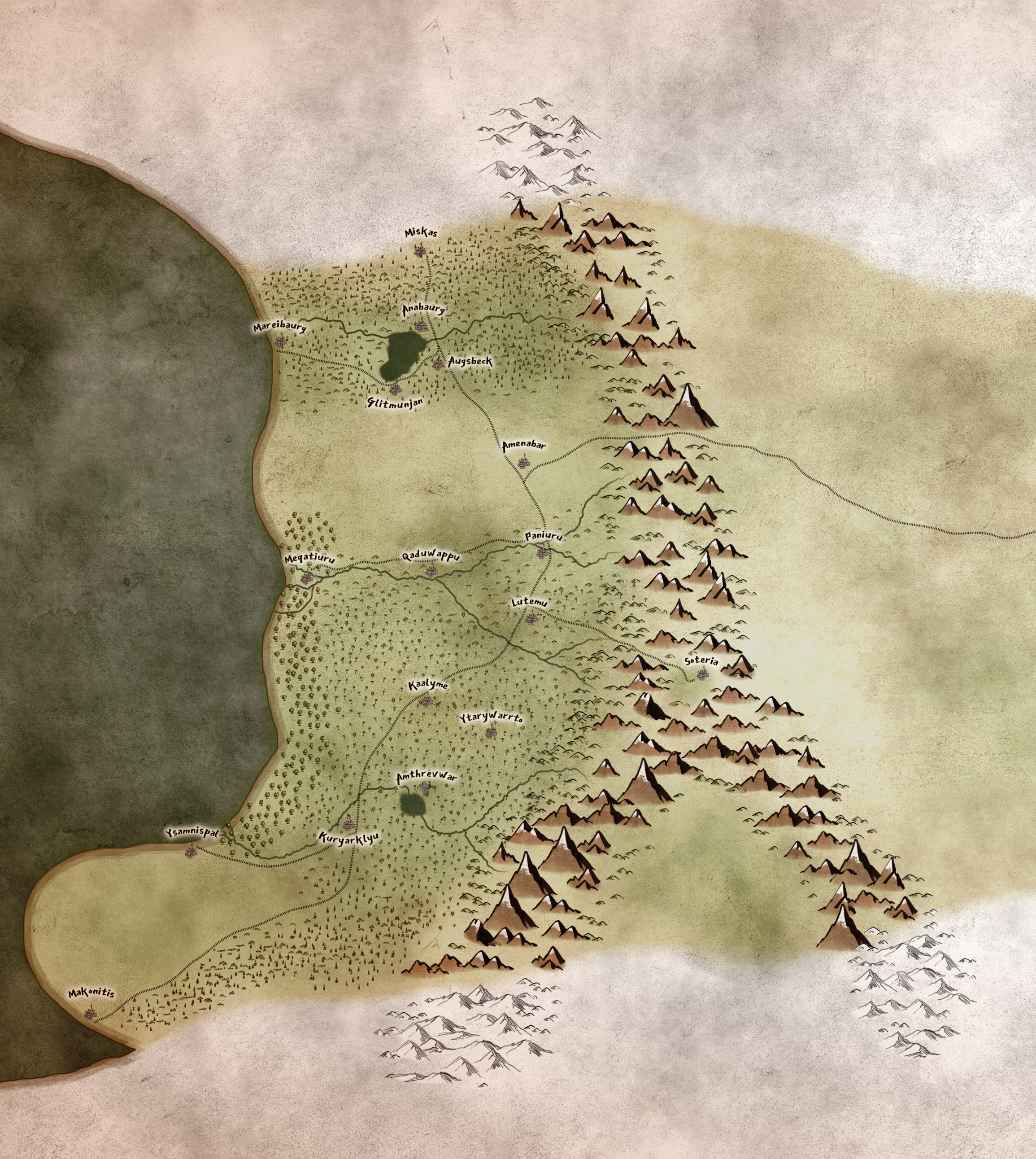
Hursag Mountains
The Hursag Mountain Range separates the Westlands from the vast expanse of the Hadpurut Desert. They stretch North well into the glaciers and in the South they swing towards the West to the sea and mark the Southern edge of habitable land, and at their widest point span nearly 120 miles East to West. Just south of the Equator stands Mount Salli, towering nearly 40,000 feet into the sky. Scattered throughout the mountainrange are abandoned Dwarven cities and Orcish forts, but for the most part the mountains are sparsely populated, clustered around mines, fertile valleys, and the passes which lead to trade routes across the Hadpurut Desert. Most of those routes are falling out of use with the construction of the Grand Imperial Railway which links the Westlands and the Eastlands across the Hadpurut Desert. Nestled in the north, inland from Frithwa Lake Soteria Monestary can be found.
Hadpurut Desert
Shielded by the Hursag Mountains, the Hadpurut is a desolate wasteland which seens no rain at all for centuries at a time. Near the mountains themselves, a handful of oases fed by aquifers, but beyond that sources of water are spread hundreds of miles apart. The Kurma people were historically the only ones able to cross the desert and it served as a barrier between the Westlands and the Eastlands. However, the first Emperor prepared an unprecendended supply train and using Kurma guides established a series of forts across the desert while travelling to conquer the East. That series of forts served as the first of several that the Empire established across the desert, and the Great Imperial Railway runs alongside the historic route. The Eastern part of the Hadpurut Desert sees sporadic heavy storms during the annual Eastern storms, however those storms spend most of their energy against the coastal mountains, so even there only plants which are able to go years between heavy rains survive.
Wetland Passages
Along both the northern and southern edges of the Hadpurut desert thin strips of habitable land can be found, fed by glacial melt during their respective summers. Life here is hard, but the presence of some water and food means that both have been used as trading passages since time immemorial. With the connection of the East and West by the Grand Imperial Railway the use of these passages has declined, but those that call them home continue to eke out a living in their freezing cold valleys.
Eastlands
The Eastern edge of the continent is defined by a coastal range that rivals the Hadpurut, but which is heavily scarred and worn by the particularly violent storms of the Annual Inversion. For most of the year the coast is bone-dry, with frequent dust storms blowing in from the west and sparse, scraggly vegetation dotting the landscape. During the Inversion, the entire costline is inundated with storm after storm, driving the people into shelters with floods and winds that scour the land. The people collect what water they can during these storms, and use it to grow meager crops for themselves. With the separation from the west by the Hadpurut, all life in the East seems foreign and exotic, everything adapted to the harsh and extreme conditions. Before the founding of the Empire, these lands were sparsely populated and were unable to put up resistance when the First Emperor made his daring march across the Hadpurut. However, with the growing demand for resources and the rich mineral veins exposed by the severe weathering of the storms, the population has boomed in recent decades with new mining towns springing up all along the costline. The population is largely reliant on imports of food from the West, however more and more they are trying to domesticate local wildlife better adapted to their conditions.